These are pictures of building and things that have been lost but scanned or a digital photo was taken of them. The aerial photos around the school are also shown in the military picture section.
This page started 8-16-2009. Latest review or modification 11/4/2019 Monday 4:05PM.

 |
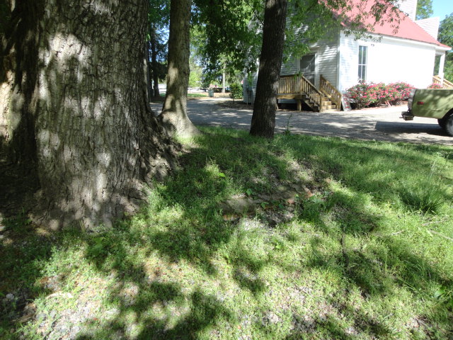 |
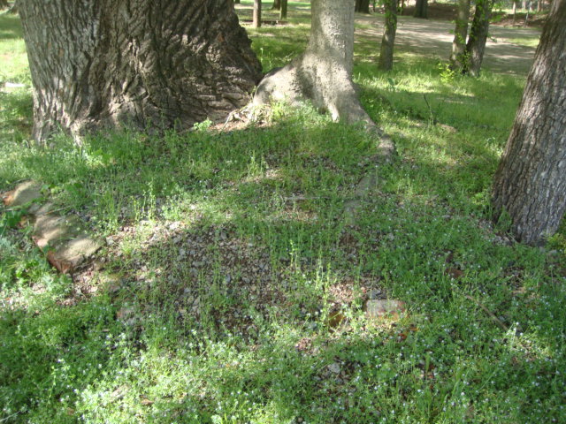
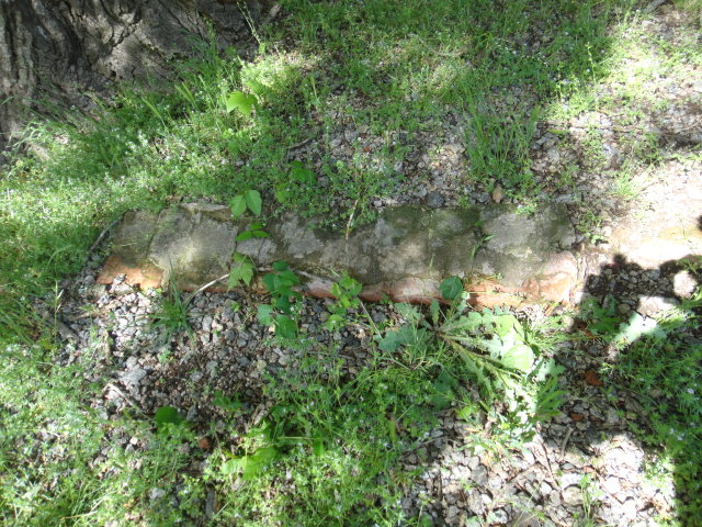
| Gin foundation at cotton wood tree Looking NE. Picture taken 26APR2020. | Gin foundation at cotton wood. View to SE. Picture taken 26APR2020. |
 |
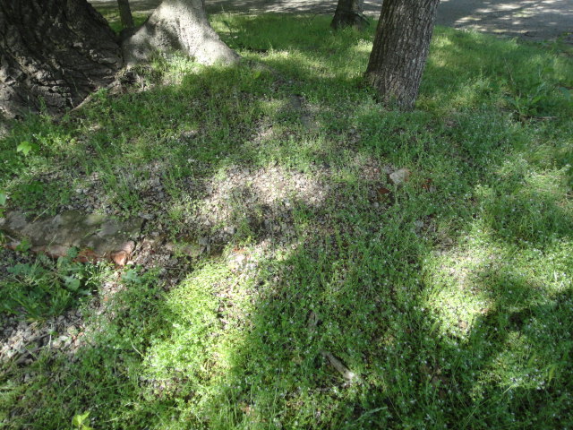 |
| Close up of Gin foundation at Cotton Wood.Looking NE. Picture taken 26APR2020. | Gin foundation at cotton wood. View to East. Picture taken 26APR2020. |
 |
|
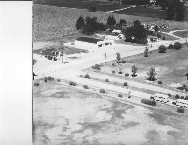
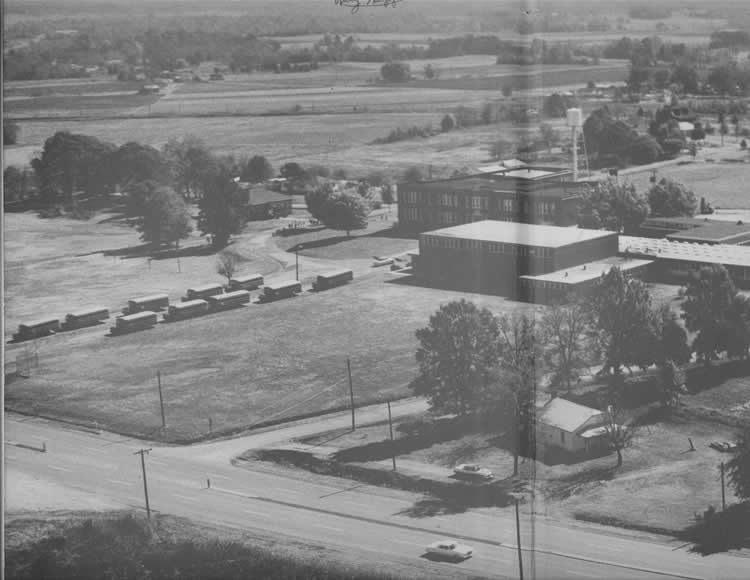
Image 0002 From inside front cover of the 1963 Harrisburg High School annual. Looking South East across NC49 on bottom and to Stallings road on top. This is the present location of Lowes Foods. Car on 49 seems to be a 1960's Plymouth. The one parked a 1956 Ford. To the left of the main school building is a maple tree that I sat against in the 9th grade and ordered by mail my first military rifle for $5.00- I still have it. In the upper left is the farm Dot Harris talked about daily driving the cows to. Her story is in the restoration section. Individual farms/houses will be added later. The High School addition and the gym had been built but the tennis courts had not been built at this time. These aerial shots were taken from a T-33 jet that almost yearly flew over Harrisburg to the delight of all the young residents. I drove bus 36. From the school the route went south on NC49 to the county line- then back North and left onto Morehead, Left on Hudsbeth, North on 49, left onto Mallard Creek, turned around at Eddie Garrisons in Mecklenburg and back to Harrisburg. There was a bridge that prevented Mecklenburg buses from reaching the Garrisons so even thought they lived in Mecklenburg they went to Cabarrus County schools. It appears this picture may have been taken around Noon. |
|
 |
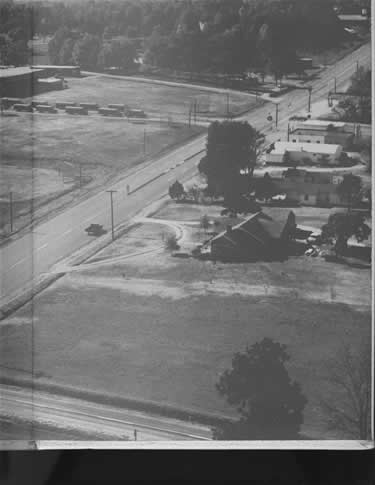 |
| Image 010 Harrisburg High looking South West. The intersection is NC49 and Roberta Mill Road. Upper right is the baseball diamond. There is a barn shown just above the water tower that has some interesting history. View is SW. It appears the picture was taken between 11:00 AM and Noon. From inside front cover of the 1963 Harrisburg High School annual. | Image 009 On the South side of 49 Harrisburg Presbyterian Church is in upper right and V. V. Howell house is just this side. Next is the Concord Telephone exchange. In the early days everyone I knew was on party lines and on a call to Concord, the only place that was not long distance, the connection was broken after 6 minutes. On the North side of 49 at the top is the old Stafford Alexander station, next is the new Stafford Alexander Sinclair station , Next is the first Fire Department, Next is the new Blume store showing the barber shop in the front of the East side, Then 2 wood frame houses behind a service station that shows in another picture , and finally the Blackwelder house. The barber shop was later moved and still is on the back of the East side of the building. CVS is now on the Blackwelder house site. View is SW. It appears the picture was taken between 11:00 AM and Noon. From inside front cover of the 1963 Harrisburg High School annual. |
 |
|
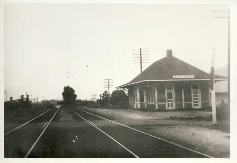
| 10007-s Harrisburg Depot location in the South East corner of Robinson Church Road and the railroad. This crossing was permantly closed around 2018. On the left is a cattle loading ramp owned by the Sims family.
|
|
 |
|
| Tallboy-18-750 This picture and all linked pictures and linked information provided by Quinton Harris. The building was built by brothers Robert and Caldwell Stafford in the mid 50's. The cafe in the left side was run by Roberts wife Mary. As far as I know this was the location of the first juke box in town. Shown in the left of the picture, across Morehead Road, is the Harrisburg Presbyterian Church Cemetery. Gas shows at $1.32 per gallon. The Jr. Davis inspection station several hundred feet North on NC49 was built later and is an almost exact copy of the Tallboy and station. The '65 blue truck and white T-Bird were Jim Smith's personal cars. It appears this picture was taken around Noon, The three cars facing Morehead Rd are for sale vehicles. Click on above picture for some linked pictures of the owner, workers, patrons and information. | |
 |
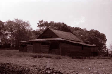 |
| Gene Davis Barn-0029 Picture by Linda McCachren for UNCC photography class 1984. Cotton wagon on left. This is the land where Blooms Grocery and the Post Office is presently located. Looking NE. As well as I remember the barn was located close to where town hall is . | Gene Davis Barn 0030 Picture by Linda McCachren for UNCC photography class 1984. Looking NW, the house is not shown but would be on the left. |
 |
 |
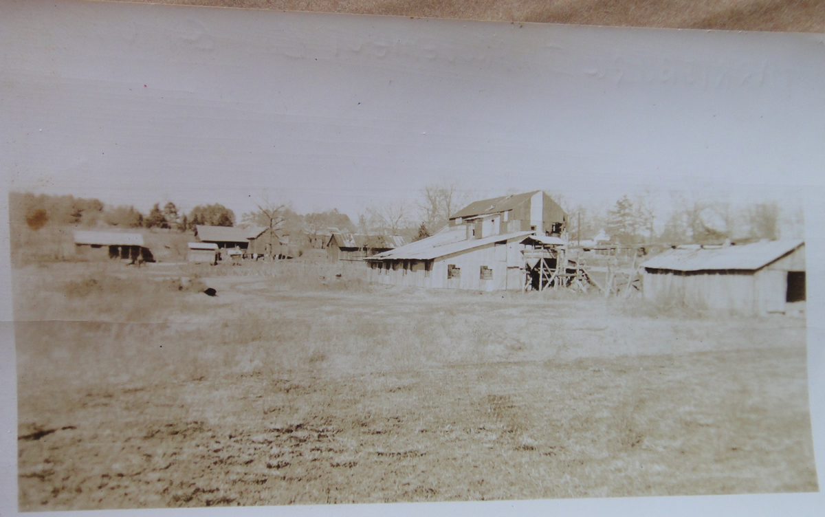
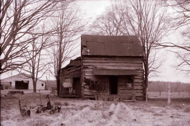
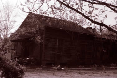
| Joe Sims Birthplace 0058 Picture by Linda McCachren for UNCC photography class 1984. Building gradually detorated and several Harrisburg residents removed some of the logs for reuse. Later the remaining logs were removed to build a cabin in the mountains. View is to the South. The Sims started building the large house on the hill viewed when crossing the tracks on Robinson Church Road going South before the crossing was closed around 2015. WWI stopped construction due to lack of wood. Joe told me several wagons were sent to Pi neville to get lumber after the war to finish the house. | Joe Sims Gin 0035 Picture by Linda McCachren for UNCC photography class 1984. This is the entrance to the gin on the North side. The load would be weighed, The wagon emptied, and then the wagon would be weighed to obtain the weight of the cotton. The wagon driver operated the suction hose and LLoyd Quay, Jr told me of his fear of being sucked into the hose when he delivered a load of cotton to be bailed. The Rail Road /Robinson Church Road crossing is off to the Right. View is SSW. |
 |
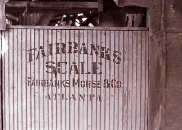 |
| Joe Sims Gin 0038 Picture by Linda McCachren for UNCC photography class 1984. View is ESE, Joe's store is behind the photographer. To the right is shown a flat car ready to be loaded with logs. Joe told me the first fire ants in Harrisburg came in on the logs being shipped out. Photograph would have been taken from in front of the original location of the Morrison/Sims restored store. | Joe Sims Gin 0043 Scales. Picture by Linda McCachren for UNCC photography class 1984. |
 |
 |
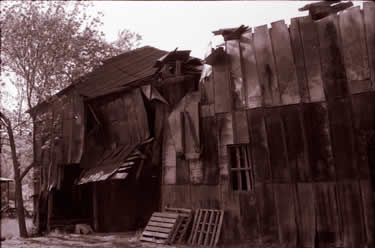
| Joe Sims Gin 0045 Picture by Linda McCachren for UNCC photography class 1984. View is NW with a corner of Joe's store roof visible on the left. | Joe Sims Gin 0046 Picture by Linda McCachren for UNCC photography class 1984. Pictured above is the Ginning equipment. View is to the North North East . |
 |
 |
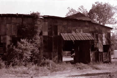
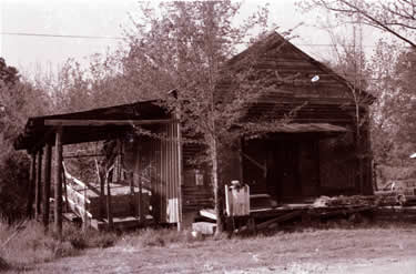
| Rail Road Ave Store 0032 This store was directly across Railroad Ave from the gin. Picture by Linda McCachren for UNCC photography class 1984. View is to the North . This is the only picture of this old store I know of. | Rail Road Ave Store 0033 Picture by Linda McCachren for UNCC photography class 1984. View is to the North. Joe Sims built the shed on the left side of the building . |
 |
 |
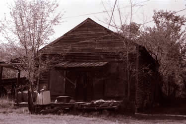
| Rail Road Ave Store 0034 This view shows the house in back of the store. Picture by Linda McCachren for UNCC photography class 1984. View is to the NW. | Zeb Stafford House 0085 Note the old style center line road lines. View is to the North and the picture was taken in the road just North Of Ted McCachren's house. Shown on the right is Emmett Sapp's house and the bottom right is the drive entrance to Robert Stafford's house who built the building that ended up being the Tall Boy. . |
 |
 |
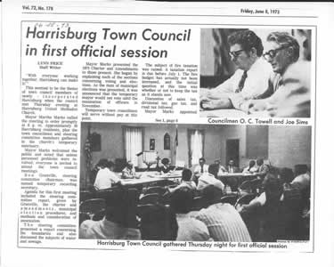
First Council Meeting 08JUN73 .. O. C. Towell and Joe Sims pictured above. |
Harrisburg Presbyterian Church Manse. This was the first brick building in Harrisburg and was built in 1931 for Rev. Wilson. It was torn down in 2001 to make room for the Harrisburg Presbyterian Church Family Life Center. |
 |
|
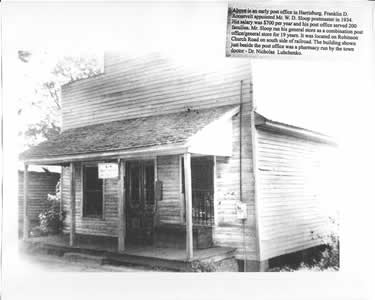
| Shown above is the Will Sloop P.O. Franklin D. Roosevelt appointed W. D. Sloop postmaster in 1934 at $700.00 per year pay. Mr Sloop ran this store for 19 years . The building visible under the porch roof to the left is the first Harrisburg Pharmacy owned by Dr Lubchenko but I am not sure if the Sloops would fill the prescriptions written by the Dr. Dr Lubchenko put all the stitches in me during my growing up years . In the 1950's the pharmacy was relocated to a place 50 feet South, 100 feet West and rotated 90 degrees to be the front addition to a small house just to the South. The large box on the right of the porch was where the mail was stored an I remember sitting on it and talking to my buddies as we walked to our homes after school. My Grandmother who lived across the street always had a bisquit for me she had made on her wood cook stove. | |